First Alert Weather: Isolated showers possible for mid-week
BIRMINGHAM, Ala. (WBRC) - Isolated showers ended up being few and far between across Central Alabama today, so all is quiet and dry on First Alert AccuTrack Tuesday night. Temperatures have fallen into the 70s this evening, so still staying mild outside. A partly cloudy sky will stick around overnight with east winds at 5 mph and morning lows bottoming out in the low 60s.
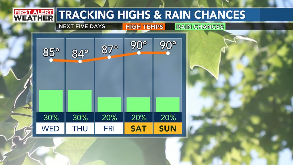
For the middle of the week, humidity will be on the rise again, bringing the chance for a few showers and storms back to the forecast. We have a 30% chance for isolated thundershowers developing on Wednesday and Thursday afternoons and evenings as easterly flow pulls in moisture from the east. As is the case during the summertime, not everyone is guaranteed to see a shower or storm each day; with rainfall totals generally staying low over the next several days, you’ll want to take the time to water your lawn and garden as needed.
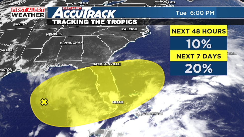
Thursday not only marks the start of June, but the start of meteorological summer and the Atlantic hurricane season. The National Hurricane Center has highlighted a disturbance in the Gulf of Mexico for a low chance of tropical development over the next several days. Regardless of whether the system becomes tropical or not, the developing low looks to eventually drift over the Florida Peninsula. Easterly flow on the north side of the low in Central Alabama will allow more clouds around for at least the middle of the week, so expect a partly sunny to mostly cloudy sky on Wednesday and Thursday. Morning lows will stay mild in the low to mid 60s with highs in the low to mid 80s.
Heading into the weekend, a warming trend will likely take hold with a First Alert for temperatures nearing 90°F - fitting as we kick-off June! Mornings will be warm and humid with lows in the mid to upper 60s before the heat cranks up during the afternoon hours. Though the eventual track of any low developing in the Gulf will ultimately determine our rain coverage for the end of the week, right now we have at least a 10-20% of isolated showers and storms around Friday through Sunday under a mix of sun and clouds. Our weather models disagree on how the pattern will evolve for the first full week of June, but at this time, we should at least start off the week pretty typical for this time of year: warm, humid, and isolated storm chances.
Download the WBRC First Alert Weather app to keep up with the latest forecast information.
Get news alerts in the Apple App Store and Google Play Store or subscribe to our email newsletter here.
Copyright 2023 WBRC. All rights reserved.